Greater Waterbury CT
Greater Waterbury CT Sign In  •   Register  •   Home

 GREATER WATERBURY GENEALOGY & HISTORY
Home  »  Genealogy & History  »  Waterbury MapsThursday, 28 Aug 2008

Waterbury Maps

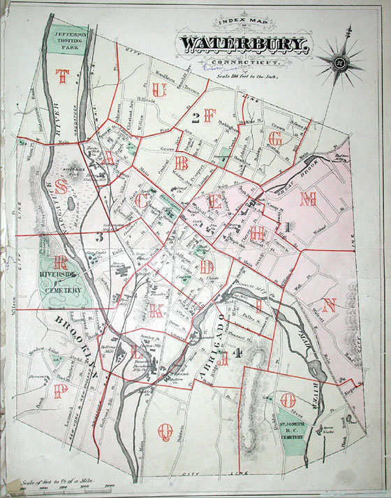
Below is one of several historic Waterbury maps that researchers will find of interest. This 1879 view of Waterbury shows 4 wards, Dublin Street (later Hamilton Avenue), Stone Street (later Sylvan Avenue), and even the Jefferson Trotting Park — an all-but-forgotten part of Waterbury's past. We will be posting several high-resolution maps available for download.

(Image below may take a moment to appear or view a larger version 1879 Waterbury Map)
Waterbury Maps

Waterbury Maps

If you have information pertaining to Waterbury Maps, please contact us.


Online Area Directory
Community Calendar
Genealogy & History
   • Cemeteries
   • Census
   • Churches
   • City Directories
   • Court Records
   • Funeral Homes
   • History
   • Hospitals
   • Libraries
   • Maps
   • Military Records
   • Neighborhoods
   • Newspapers
   • Photographers
   • Photo Albums
   • Schools
   • Vital Records
   • Web Sites
Surname Registry
Visit Greater Waterbury
Real Estate
Sports & Recreation
News & Weather
Add A FREE Listing
Search 1930 Census Records
Visit GenealogyPays to win!

About Us    Advertising    Contact Us    Overnight Website    Town Profiles    Employment    Privacy Policy    Terms of Use    Site Map
Copyright © 2001-2008 by Mattatuck Consulting, LLC.   All Rights Reserved.


 Trumbull Mall
 Fairfield County CT
 Shopping at its finest!

 www.trumbullmall.com


 Trumbull Marriott
 Great Central Location,
 Best Rates Anywhere!

 www.trumbullmarriott.com


 Milford Mall
 Westfield Connecticut
 Post Mall Milford CT.

 www.milfordmall.com